

I just noticed a strange bug on my todays's trip, which was going through a tunnel. On the web interface, the display is normal, but on the iphone it shows a horrible climb, that couls discourage people from taking the route (max 27 % !!!):
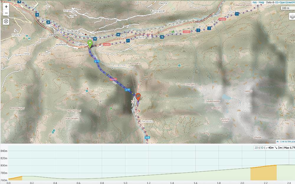
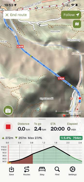
https://cycle.travel/map/journey/1052601
Best regards,
Cécile


Comments
Hi Cécile,
Using your route, I can see a very similar effect in the android app vs the website.
Interestingly, while the Max gradient is similar, there are small differences in the elevation gain & loss across the IOS & Android versions.
A couple of observations, if may, for anyone worried about elevation mumbers.
Bridges, viaducts and tunnels can always be a source of confusing information and anomalies are always worth checking out in some more detail.
Max gradient is a useful tool but doesn't always paint an accurate picture. I've come to think of it as general guideline but that 'scary' numbers are either a very short snapshot of one particular point or the result of confusing data & often a combination of the two. In many places, relatively gentle long climbs can have a 'max gradient' figure seemingly based on steep hairpin bends.
Similarly, my gps unit will tell me my top speed on a ride - which is never a true indication of my speed over the day.
One useful piece of info on the map is that it is an official cycle path - EV7 the Sun Route - and despite some issues with EV routes we can be pretty confident that they won't send us up (or down) 27% gradients. I'd be a lot more cautious if this route was on a 'normal' road.
To check, where streetview is available, we can add a VP (in the app) at the start of the big climb, save the route and open it on the website. In this case, streetview is pretty clear that there isn't a significant climb, especially when starting from the end (the tunnel opening).
Indeed, I wasn't too worried myself. Actually, the roure in the tunnel, while being far from idyllic and romantic, is well managed, solidly separated from traffic and very safe. Well done EV7 :-). Dunno if adding something like an altitude point at the middle of the tunnel in OSM or something like this would help solving the issue, but on the other hand I am somewhat reluctant at tweaking OSM only to obtain the right behavior from a 3rd party app.
Funnily enough I noticed the exact same bug on the exact same tunnel last year. Enjoy the rest of the Alpe Adria! Such a fantastic cycle route.