
Become a supporter
Hello,
I have a problem with a forest road, that cycle.travel by no means won't allow me to use.
See journey:
https://cycle.travel/map/journey/247447
I want to go the grey dotted way that is indeed an unpaved road like all the other roads in that forest. And yes, cycling this road is allowed. When switching to the OSM overlay I can see no difference between the road I want to go and the route that is proposed by cycle.travel. So could the the road, I want to go, may have a wrong category and therefore is not taken into account for routing? It would be nice, if someone can look after this.
Best regards
Holger
Hi, it would be nice to have the possibility to draw a track in a pathless area. This would be helpful in areas that are not fully covered in OSM (like the Bavarian Forest). Example:
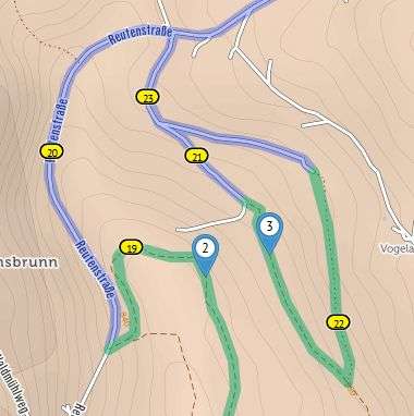
There is indeed a small path between the via-points 2 and 3 but I have found no solution in cycle.travel to draw my track directly between these two waypoints (as the path is missing in OSM). So instead of 200 m pushing I got a 2 km detour. (I will look for someone who can insert the path to OSM, but unfortunately it is not the only example.)
Best regards, Holger


Made in the Cotswolds. Published by Éditions Système D Ltd.
Log in with your cycle.travel account:
| Password |
Or simply use your account on:
