
Become a supporter
The longer route off the Tende and onto the dramatic Via del Sale (VdS). The Via del Sale is a long, quite remote section of track through a karst limestone landscape. It's one of the most incredible mountain roads in Europe. The Refugio Don Barbera isn't too far from the Col Tende itself, a couple of hours ride on a good day.
The descent off the Via del Sale via the Pas du Tanarel / Monte Saccarello area is very rough for a couple of kms – rocky MTB terrain, though rideable with care on 650B 'Road Plus' type bikes – and it’s a long, arduous descent to La Brigue with some rolling terrain in the woods.
At the time of writing (July '21) there are roadworks in the Roya valley, related to the damage caused by Storm Alex.
Between Saint-Dalmas and Fontan you have a 6 km long portion (downhill, on gravel track and tarmac) where traffic is one direction at a time.
At night and on week-ends, traffic can pass every hour between h00 to h15 from Saint-Dalmas to Fontan, and between h30 to 0h45 in the other direction. On weekdays the road is closed for works and only one crossing at 12:00 downwards and 12:30 upwards is allowed from 07:00 to 17:00.
**********
After La Brigue is the big climb to the Fort de la Forca and the Col de Turini, using a new road for the TNR. It's a tunnelled, balcony road that change into a dirt road and onto the Circuit de l'Authion towards the top.
You can see the sea from the top if it’s a clear day. You can even smell the sea air sometimes... the coast isn't that far away now.
The Roya valley between the Col Tende and the start of the climb to the Fort de la Forca is another potential supplies desert if you arrive there late. Restaurants are the main options though there is a Spar shop in Tende itself if you back-tack up the valley on this route. Worth studying the options on the map perhaps.
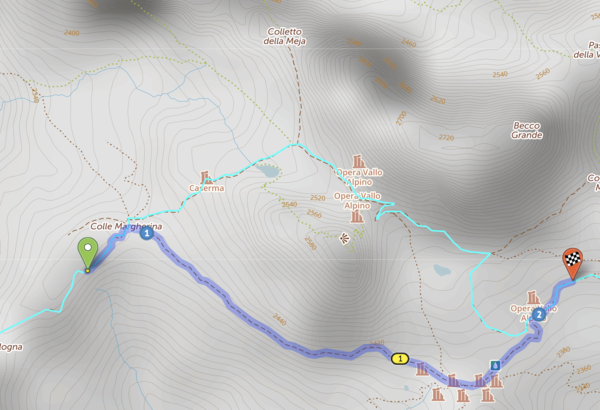
Hi, while plotting the established Torino-Nice gravel route, I found that cycle.travel would not allow routing on this segment. I am not familiar enough with OSM to understand why. Bicycles are permitted and I didn't think the surface condition would preclude routing. Perhaps the "very_bad" smoothness? https://www.openstreetmap.org/way/50894205
https://cycle.travel/map/journey/389779
Below is an image of the desired route (in light blue). Any insight would be appreciated, as it will help me to learn how to best use OSM and c.t routing. Thanks!
Our original route past Chialvetta with the rough stuff section into Little Peru. A notable hike/push on footpaths in beautiful surroundings beyond Chialvetta rewards with some #bunkerresearch at the top and a dramatic unveiling of the altopiano from the Passo della Gardetta. If you rode the Col d’Izoard rather than the hike-a-bike option there and still want to earn your Rough Stuff Alps points on this route, then this is the route to take.
The route continues on a long descent to Demonte, a bike path road to Borgo San Dalmazzo and good resupplies at Limone Piemonte. It follows the same route as 4.2 after the Gardetta area, using a flat route between Demonte and Limone Piemonte.
Both 4.1 and 4.2 routes pass two bike shops around the 75km point, on the way out of Borgo San Dalmazo.
This route includes the high point of the ride, the 2744m Col Agnel / Colle dell'Agnello which also marks the France-Italy border, and the stunning and "memorable" Strada Cannoni along the Varaita-Maria ridge. A section of the Cannoni descent features the biggest gravel (aka rocks) on the route, it’s a challenge on any bike but it’s been done on 35mm tyres in the past (it’s not recommended...). Don’t get caught without spare inner tubes - it's rocky and not typical gravel bike terrain at all. The roughest few km of the descent takes you onto a relaxing, almost flat valley road - a welcome breather in between the big mountains. The ride along the Val Varaita is particularly nice if you go all the way to the Gardetta hike-a-bike (4.1) turn-off.
There is also the linked SCR.2 file within the collection. SCR.2 bypasses the rough section of the Cannoni. There is also the fully safe, very pretty (unrouted/off-route) SP335 road descent off the Col Sampeyre if needed – both re-join this main route file (3) within 10km of its end.
A classic road climb over the Col d'Izoard takes you to the Fort Queyras / Chateau Ville Vieille area. The Izoard is a truly beautiful climb and one that doesn’t feel as hard as its height and fame may suggest - it's a different matter on a hot day though.
Look out for the memorial to Louison Bobet and Fausto Coppi within the incredible scenery of the Casse Deserte at the top.


Made in the Cotswolds. Published by Éditions Système D Ltd.
Log in with your cycle.travel account:
| Password |
Or simply use your account on:
